Steel pipeline inspection and location mapping are complex workflows that require mobile data collection of photos and GPS location coordinates, in addition to integration with Geographic Information Systems (GIS) databases and mapping. It also necessitates integration with company business rules such as crew scheduling, inspection documentation, and crew certifications.
This article explores the problem and today's most innovative technology that enables digital workflow management for metal pipeline inspections.
The Problem: Steel Pipeline Inspection and GIS Mapping
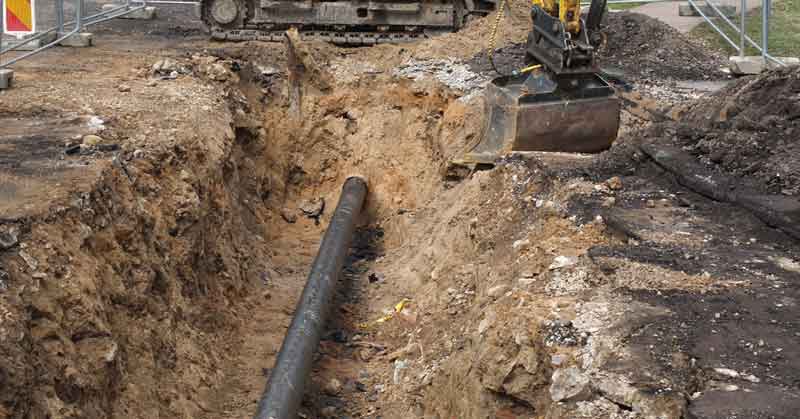
A common reason to excavate a steel pipeline is a new road, railroad, or an electric or gas line installation nearby. When a steel pipe is excavated the coating may be damaged during the dig. This is an opportunity to inspect the pipeline for any ongoing corrosion, pitting, or physical damage.
It is also an opportunity to collect accurate Global Positioning Systems (GPS) location information for the pipeline. When the pipeline was originally installed, accurate GPS systems may not have been commercially available.
In addition, depending on the decade the pipeline was installed, transmission pipeline locations can be off by as much as 50 feet from their documented locations. Modern GPS systems are accurate to within a few inches, providing much greater accuracy for future service, maintenance, and response to emergency events.
The Solution: Digital Workflow Management for Pipeline Inspection
CartoPac Workflow Manager (CWM) software manages the step-by-step data collection workflow for your pipeline inspections with a flexible “Full Stack” software suite, from mobile forms and data collection to back-office integration tools.
CartoPac includes forms and logic for specific tasks to guide the field crew through the workflow while enforcing company-specific business rules. The goal is to map and manage underground pipeline infrastructure securely, accurately, and economically.
Unlike mapping aboveground infrastructure, mapping underground presents unique challenges for accurately and economically collecting data in 3D. CartoPac develops mapping solutions that provide positional accuracy to approximately 4 in. (10cm) in both pipeline location and depth.
A complete understanding of the corporate business rules and regulatory processes is key in providing efficient inspection and mapping solutions, and in developing a comprehensive infrastructure management plan.
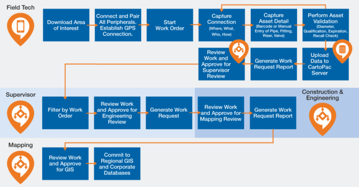
An example workflow is shown in Figure 2. CartoPac’s mobile software solution provides a step-by-step guide and integrates the needs of field techs and supervisors.
As shown in Figures 2 and 3, CartoPac coordinates field techs and supervisors by enforcing business rules, filtering, and scheduling workers, jobs, and projects. Supervisors can review and approve work and generate reports.
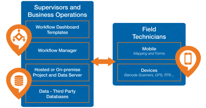
CartoPac Enterprise is a full-stack software suite with mobile forms, integrated data collection such as barcodes and GPS, and modules for integration with existing data GIS and business operations databases.
Another important feature of CartoPac is the ability for customers to use third-party IO devices. For example, you may need to include a pressure test device for pressure test compliance and validation. As an open, flexible platform, Cartopac Enterprise easily integrates many types of devices.
| Module | Benefits | Key Features |
|---|---|---|
|
CartoPac Mobile
|
|
|
|
CartoPac Workflow Manager
|
|
|
|
CartoPac Server
|
|
|
|
Data |
|
|


CartoPac has extensive experience working with field crew needs analyses and requirements gathering, in addition to solution development, testing, and support. This enables CartoPac to provide unique and often custom solutions for customers.
Our professional services group often customizes the solution to integrate unique business rules, and database and hardware requirements.
Using the latest data acquisition and mapping technologies, the CartoPac platform helps meet clients’ business needs and ensures that the solution is delivered within time and budget.
Read more about CartoPac’s digital workflow management for as-built and new construction surveying.
Learn about the latest version of CartoPac Enterprise software.