
Custom workflows, real-time visibility, and faster field-to-GIS integration.
About the Utility Operator
This large gas distribution utility serves millions across in the United States, operating in regions marked by rapid growth and challenging field conditions. Their team needed a better way to manage data for new gas utility construction and repairs.
Their focus includes new residential infrastructure projects—burying natural gas pipelines throughout wide open dirt fields before homes are built. While they oversee repair and replacement projects, their primary focus is new construction.
The Challenge: Paper-Based, Time-Consuming Processes
Before CartoPac, field crews relied on tape measures, pens, and hand-drawn sketches to map asset locations. These drawings were passed to engineering and GIS for manual entry—a process that often took 9–12 months to complete.
Paper processes also created risks for:
- Delayed access to asset data
- Inaccurate or incomplete field records and location data
- Compliance gaps
- Inefficient collaboration between field and office teams
“The most important thing is always getting gas to the customer—but with the old system, the documentation could lag behind for months. CartoPac speeds the whole process up…. Data could be collected today, reviewed tomorrow, and posted on Thursday. That’s how fast things can hit the map if everything lines up.” — Aaron Cysensky, CartoPac Product Manager, American Innovations
The company continues to generate paper copies in parallel with collecting data digitally as part of a gradual change management strategy. CartoPac is increasingly seen as the source of truth across the organization.
Why CartoPac Was the Right Fit
The company conducted a two-year request for proposal (RFP) process with demos and pilots across 4–5 sites. Ultimately, CartoPac's configurability sealed the deal.
Unlike competitors offering rigid, out-of-the-box solutions, CartoPac allowed crews to maintain their workflows. Over four years of continued collaboration have gone into refining the implementation, ensuring effective business rule implementation.
“It’s been a really good experience working with the CartoPac team—refining the solution to fit our needs and helping us make the leap from old paper-based methods to a digital way of documenting what we install.” — Construction Superintendent
Learn about the CartoPac Gas Distribution As-Built Solution
Implementation Challenges
The transition from paper to digital wasn’t without challenges:
- IT roadblocks were addressed by moving the utility to a CartoPac hosted environment.
- Performance optimization became an ongoing priority to ensure speed and reliability as usage scaled.
To support a growing user base and ensure long-term success, the company became the first utility to adopt CartoPac’s Total Priority Support (TPS) program, now in its third year. TPS includes 12-hour-per-day extended support, full mobile device and GNSS hardware management, managed software updates, and secure, authenticated user and contractor access.
The Results: Efficiency, Accuracy, and Confidence
Since implementing CartoPac, the utility has seen major improvements in both efficiency and data quality:
- Turnaround time dropped from 12 months to about 2 weeks
- 60+ metadata points captured per asset, creating complete digital audit trails
- Near real-time cross-department visibility
- Compliance with PHMSA plastic pipe guidelines for traceable, verifiable, and complete data sets
“The most recent version of CartoPac is the best we’ve had. The accuracy is second to none—we’re locating underground gas lines within a couple of inches. That kind of precision is huge for future maintenance, material investigations, and even crew accountability.” — Lead Construction Specialist
“The best part is the pinpoint accuracy. What I like most is that it makes the next person’s job easier when mapping it out.” — Facility Data Collector
An Unexpected Win: Correcting 60-Year-Old Pipeline Records
As crews use CartoPac to document new assets, they’re also uncovering and correcting errors in legacy pipeline maps.
This process, known as conflation, enables the GIS team to update decades-old records with accurate locations—making the entire network safer and more reliable.
“You may find out where we think it is—is not where it truly is. It could be 10, 15, even 40 feet off. You could be on one side of the street versus the other.” — Construction Superintendent
This unexpected benefit is helping the company bring decades-old infrastructure records into the digital age—improving confidence, safety, and long-term reliability.
From the Field: Simple Tools, Big Impact
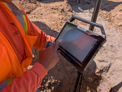
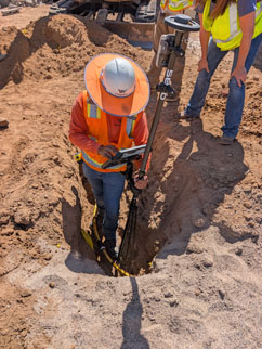
“I use the GNSS system to collect satellite data, my tablet to collect internet data, and a barcode scanner to grab part data—it all syncs together to make the data very accurate.” — Facility Data Collector
This Facility Data Collector is a boots-on-the-ground crew member who’s become confident with digital tools—not because they're a tech expert, but because CartoPac makes it easy. They achieve pinpoint accuracy with tools that fit their workflow in the field, eliminating the need for guesswork.
The Bottom Line: Built for the Way Field Crews Work
CartoPac hasn’t just improved data integrity—it’s transformed the way this natural gas utility works in the field. Crews are working faster, with greater accuracy, and have near real-time access to the data they need to keep projects moving.
Projects close sooner, compliance is easier, and the audit trail is complete.
Want to see how CartoPac can streamline your field operations?
Learn about the CartoPac Platform or contact us!